As part of the Transit Neighborhood Plans program, City Planning is developing regulatory tools and strategies for the areas around the Purple Line Phase 1 Extension stations at Wilshire/La Brea, Wilshire/Fairfax, and Wilshire/La Cienega. These tools and strategies aim to encourage transit ridership, promote job creation, enhance the urban built environment, and focus new growth and housing in proximity of transit and along corridors while protecting the character of single-family neighborhoods.
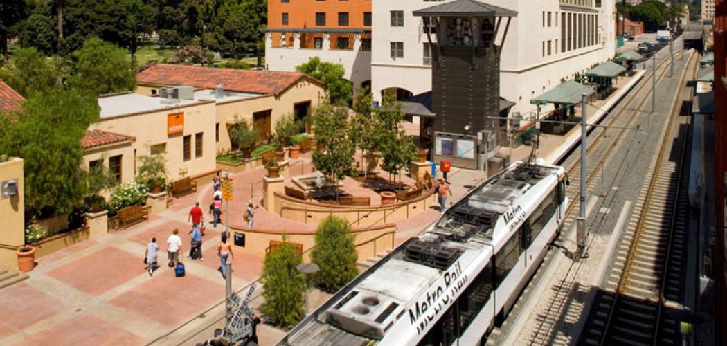
The Metro Purple Line is a subway line that currently consists of eight stations, beginning at Union Station in Downtown Los Angeles and terminating at the Wilshire/Western Station in Koreatown. The Purple Line Extension will extend the line west, adding seven new stations through Miracle Mile, Beverly Hills, Century City, Westwood, and West Los Angeles. With trains running every 10 minutes, the completed Purple Line Extension will be the fastest and easiest way to get to UCLA from downtown Los Angeles. Similar to the Exposition Line, this line will become a critical east-west connection in the city. For more information on the Purple Line Extension please visit http://www.metro.net/projects/westside/.
The first phase of the three-phase extension began construction in 2014 and is anticipated to open by 2023, and includes the following new stations:
The Wilshire/La Brea Station is the first of the three new stations of the Purple Line Extension. The residential neighborhoods of Park La Brea, Hancock Park, and Miracle Mile surround the station, with corridors of active commercial, retail, and office space located along Wilshire Boulevard and La Brea Avenue.
The station is located within the Wilshire Community Plan Area, with nearby special districts such as the Miracle Mile Community Design Overlay, the Miracle Mile North Historic Preservation Overlay Zone, the Hancock Park Historic Preservation Overlay Zone, and the Park Mile Specific Plan.
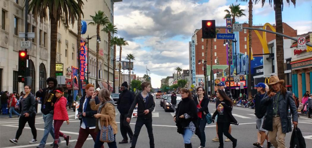
The Wilshire/Fairfax station is located in the Miracle Mile neighborhood, adjacent to several major city landmarks including the La Brea Tar Pits and the Los Angeles County Museum of Art (LACMA). The station is located at the intersection of the main commercial corridor on Wilshire Boulevard, which has several medium- and high-rise commercial and office buildings, and smaller-scale Fairfax Avenue, which has several single-story restaurants and stores. There are also several multiple-family and single-family residential neighborhoods near the station, including Park La Brea and Carthay Circle.
The station is located within the Wilshire Community Plan Area, with portions of it additionally located in special districts such as the Miracle Mile Community Design Overlay, the Carthay Circle Historic Preservation Overlay Zone, and the Beverly Grove Residential Floor Area district.
The Wilshire/La Cienega station is located at the intersection of Wilshire and La Cienega Boulevards in the City of Beverly Hills. The surrounding land uses are predominantly single-family residential, with vibrant commercial corridors along Wilshire and La Cienega Boulevards. Within the City of Los Angeles, the station area is largely multiple-family and single-family residential, with commercial buildings along Wilshire Boulevard and portions of San Vicente and La Cienega Boulevards.
The City of Los Angeles will work closely with the City of Beverly Hills to coordinate planning efforts around the station. The City of Beverly Hills is currently developing a community plan for the surrounding area that will implement the community’s vision for the neighborhood and address issues such as urban design, mobility enhancements, land uses, and connectivity to the new subway station. For more information on the City of Beverly Hills’ community planning efforts, please visit here.
The station area within the City of Los Angeles is located in the Wilshire Community Plan Area, with portions of it additionally located in special districts such as the Miracle Mile Community Design Overlay, the Carthay Circle Historic Preservation Overlay Zone (HPOZ), the South Carthay HPOZ, and the Beverly Grove Residential Floor Area district.
The Purple Line Transit Neighborhood Plan, also referred to as the Purple Line TNP, is a long-range planning effort around three future Metro Purple Line subway extension stations in the Wilshire area at: Wilshire/La Brea, Wilshire/Fairfax, and Wilshire/La Cienega to regulate land uses, zoning, and design of new development. The Purple Line TNP aims to foster a mix of uses around the transit stations that will encourage transit use and improve mobility for everyone. Directing new housing and jobs to transit-served areas is an overarching principle of the City’s General Plan and the Wilshire Community Plan, with the goal of providing residents and employees greater mobility choices and reducing automobile dependence and greenhouse gas emissions that contribute to poor air quality and climate change.
What properties are affected by this Project?
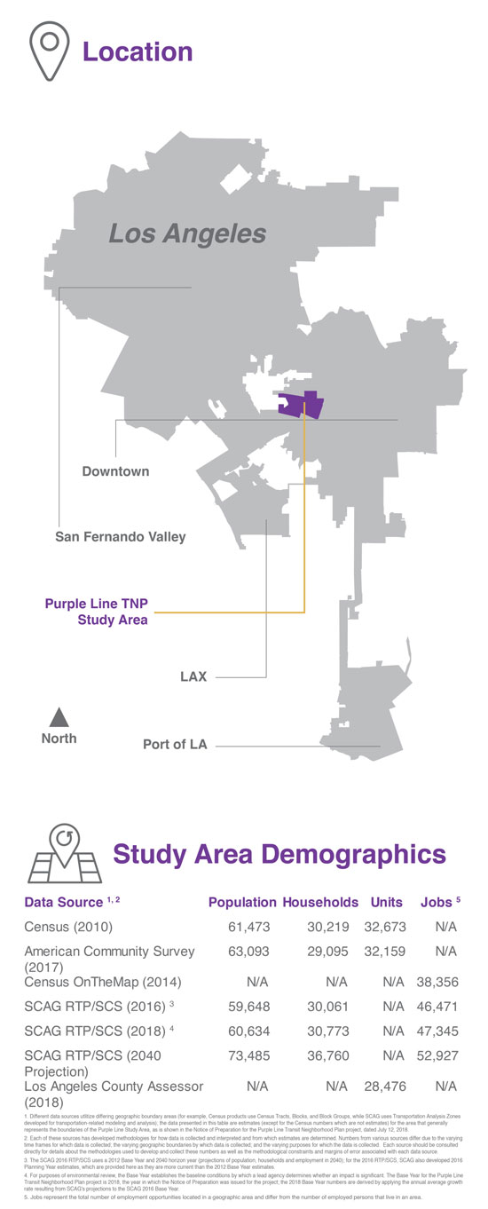
The Purple Line TNP study area encompasses the areas within the City of Los Angeles generally within a half-mile radius of the Purple Line Extension stations on Wilshire at La Brea, Fairfax, and La Cienega. Land use and zone changes are currently proposed for select commercial and multifamily parcels near the stations.
What are the components of this planning effort?
The Purple Line TNP is not a Specific Plan. This planning effort will apply new zones in select parcels around the three Purple Line TNP stations. The new zones will regulate uses, form, intensity of development, and design to maintain and improve the aesthetic quality and character of Purple Line TNP neighborhoods, and ensure compatibility between new developments and the existing context, through objective criteria embedded in the zones.
What does this Project regulate?
Through the use of the new zoning code, the Purple Line TNP effort can regulate:
Future proposed development utilizing the new zoning code would be subject to affordable housing provisions as well as a variety of public benefits, such as publicly accessible open space, transit amenities, and vehicle trip reduction for commercial projects, in exchange for development incentives.
Will anything be built as a result of this planning effort?
The Purple Line TNP planning effort sets the range of uses and the size of new development allowed in proposed subareas within the study area and does not propose any development projects. Under the Purple Line TNP, each proposed development project would continue to go through development permitting processes.
For the latest plan updates, visit the "Updates" tab.
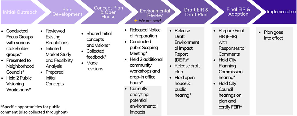
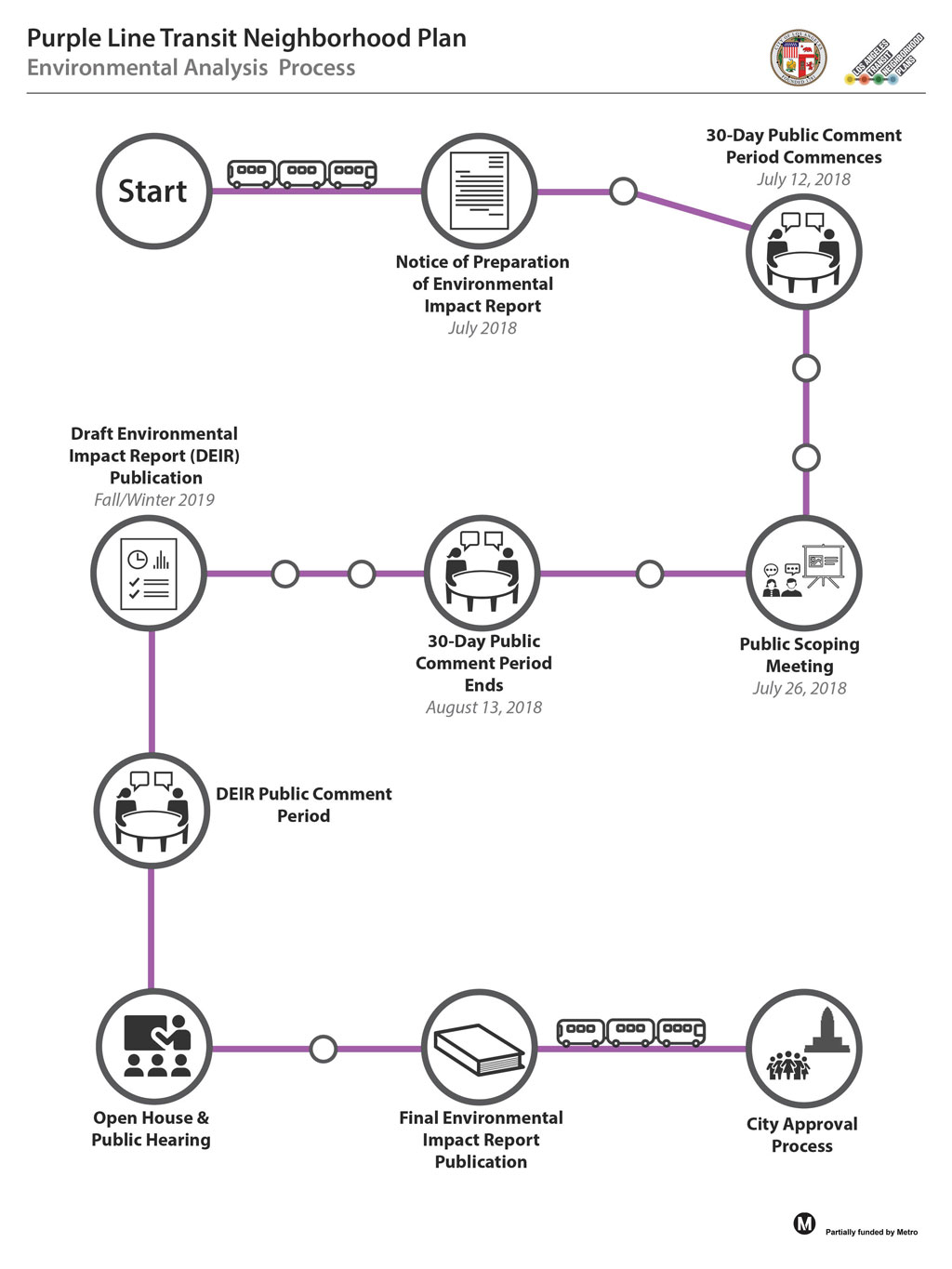
The environmental review process, outlined in the diagram below, began with a Notice of Preparation (NOP) issued on July 12, 2018 along with a public Scoping Meeting held on July 26, 2018.
Materials from the Scoping Meeting may be found below:
Community Plan
Citywide
Specific Plans
HPOZs (Historic Preservation Overlay Zone)
Other Documents
A component of the Land Use Element. It focuses on a particular area or community within the City. (e.g. Hollywood Community Plan)
The number of residential units permitted per acre of land.
The ratio of the gross floor area of a building to the area of the lot where it is located. Watch FAR video.
An element of the City's General Plan that states the goals and policies on a number of topics related to growth and services. All General Plan Elements adopted by the City need to be consistent with the Framework.
Establishes the height and FAR limitations.
Development of vacant or underutilized land within urbanized areas.
Land Use designates the intensity of the different uses of land, such as residential, industrial, commercial and open space. Each land use designation has a list of corresponding zones.
A law or statute enacted by a city government. Zoning is established by ordinance.
A committee of five or more citizens who are appointed by the City to review matters related to planning and development.
A state law requiring state and local agencies to analyze the potential impacts of their actions on the environment, disclose their findings to the public, and to mitigate impacts where feasible.
Type of environmental review prepared when the City determines that a project may potentially have significant environmental impacts.
A General Plan is the City's guide for its future growth and development. Every city is mandated by the state of California to adopt a General Plan. The lifespan of a General Plan is typically 20-30 years and must be updated periodically. The General Plan is required to cover seven topics called elements, such as Land Use, Housing and Safety, but can include optional ones as well.
Zones or regulations that will be in addition to the zoning regulations and will be a part of the Community Plan that will make sure the goals of the Plan are met when new development takes place.
The public and quasi-public facilities required in order to serve the development and operational needs of a community, such as roads, public transportation, water and sewer systems.
A project that combines compatible uses within the same structure, such as residential uses above ground-floor commercial space.
Development that is located near transit. The City’s General Plan encourages locating new housing and businesses near transit as a way to give people the option of using transit and getting around by travel means other than a car (e.g. walking, bicycle, public transportation).
Zoning determines the uses permitted on a parcel and provides regulations for development, including height, bulk and setbacks.
Winter 2021 Update:
Throughout 2020, the COVID-19 pandemic altered everyday life in Los Angeles, underlining the importance of maintaining a sense of community, both as a nation and as Angelenos. City Planning continues to work and maintain operations while being adaptable and responsive. As part of assessing our work programs given a reduction in resources, we are aligning some efforts while fostering more inclusive and equitable strategies to support community engagement and input on core policies.
For these reasons, LA City Planning will be pausing our current efforts on the Metro Purple Line Transit Neighborhood Plan (TNP) until the Wilshire Community Plan program commences. Aligning the Purple Line TNP with the larger update to the Wilshire Community Plan will allow for a holistic and comprehensive approach to long-range planning in this part of the City, and along the larger Purple Line (D) Line corridor. The larger Community Plan update process will present a stronger opportunity to augment the Purple Line TNP with supportive Community Plan policies and programs that can address concerns about potential displacement, and protection of affordable and rent-stabilized housing. It will also allow for greater consideration as to how best to plan for growth in employment and housing across the large Community Plan area.
During the Summer of 2020, Los Angeles City Planning shared a Project Summary Report and interactive StoryMap for the Purple Line Transit Neighborhood Plan (TNP). The report highlighted revisions to the planning concepts that were informed by stakeholder input received throughout the project thus far, including the 2019 workshops, office hours, community survey, and numerous comments.
With respect to the work completed thus far on the Purple Line TNP, we anticipate continuing the conversation where things have paused, and call your attention to the links provided above. We remain committed to this work program even with the economic and staffing impacts that have resulted as a result of this pandemic.
We would like to thank you for your involvement in the Purple Line TNP and hope that you will continue to work with us on this effort when we resume work on this project in the near future. In the meantime, while we will not be actively working on this project, feel free to submit any comments or questions to Priya Mehendale via email to priya.mehendale@lacity.org.
Below are the latest project documents for the Purple Line Transit Neighborhood Plan, including notes and presentations. As this is a work in progress, we encourage your input on these preliminary recommendations. You may send a message to Planning staff directly via email or mail (see page for information).
To submit a comment on the plan concepts, use the Online Comment Submission Form.
Please sign up to stay up-to-date on the progress of this important neighborhood planning initiative.
Summer 2019 Updates:
In February and March of 2019, in conjunction with the Winter 2019 community engagement efforts, City Planning staff conducted an online survey regarding the Purple Line Transit Neighborhood Planning effort. The goal of the survey was to assess stakeholders’ opinions regarding the project and related issues pertaining to housing, mobility, and urban design.
All survey responses received inform the Department’s planning process and analysis. The survey results have been separated into two categories for analysis: responses that have quantifiable data, and responses that have qualitative elements from open-ended questions.
Thank you for your comments!
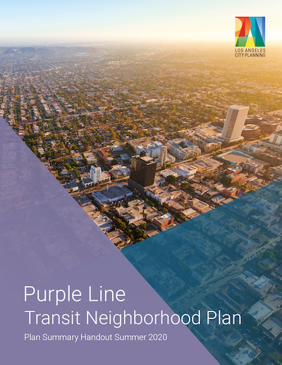
Staff shared the below Plan Summary Handout. While the Handout contains much of the information that has been previously shared with stakeholders, it also includes revisions to the planning concepts that were informed by input received throughout this project thus far, including the 2019 workshops, office hours, and community survey.
This summer Los Angeles City Planning shared a Project Summary Report and interactive StoryMap for the Purple Line Transit Neighborhood Plan (TNP). The report highlighted revisions to the planning concepts that were informed by stakeholder input received throughout the project thus far, including the 2019 workshops, office hours, community survey, and numerous comments.
Contact the Purple Line Transit Neighborhood Plan Team for general questions regarding the Plan update.
Craig Weber
Principal City Planner
craig.weber@lacity.org
(213) 978-1311
Priya Mehendale
Senior City Planner
priya.mehendale@lacity.org
(213) 978-1380
To submit a comment on the plan concepts, use the Online Comment Submission Form